Focus on afram plains
BACKGROUND
AFRAM PLAINS
Overview of the geographic area
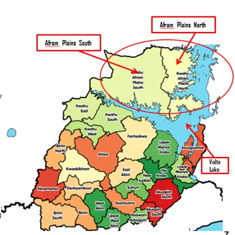
The subject area covers three districts, namely Afram Plains South, Afram Plains North and Sekyere Afram Plains North Districts. The districts are headed by District Chief Executives, who are the representative of the President
The land is generally undulating and rises about 60 metres to 120 metres above sea level. The only high ground is in Bonkrum. The subject area is drained to the south by the Afram River and the Volta River to the east which flow continually throughout the year and can be used for both domestic and agricultural purposes. Several other seasonal streams are found in the subject area. The pattern is largely dendritic flowing in the north-south direction.
Overview: Physical Features
The subject area falls within the savannah vegetation zone comprising the savannah transitional zone and savannah woodland which is characterized by short deciduous fire resistant trees often widely spaced and a ground flora composed of grass of varying heights which is associated by two main rainfall seasons occurring in June and October; the first rainy season starts from May to June and the second from September to October. The mean annual rainfall is between 1150mm and 1650mm. the dry seasons are distinct starting between November and late February. Temperatures are found to be hot ranging between February and March (36.8 oC and 36.6 oC on the average, respectively), while the coldest ones are December and January (19.9 oC and 20.1 oC on the average, respectively). Relative humidity is generally high throughout the year, ranging between 68.2% to 71.6% in the dry season and 81.6% and 71.6% in the wet season.
Forest reserves constitute about 15% of the entire surface area. Some commercial trees species contained in the forest are Milicia excels (Odum), Sterculia rhinopetala (Wawa), Terminalia superba (Ofram), Khaya ivoriensis (African Mahogany), Antiaris toxicaria (Kyenkyen) etc. the major soils in the district are the Swedru-Nsaba-Offin Compound. Dominating this soil group is the Swedru series which are mainly red silty, well drained, deep gravel-free silty loams and silty-clay loams. The Nsaba series are yellowish red silty clay loam, moderately well-drained, very shallow, and rocky. The soils are suitable for the cultivation of both food crops (cassava, plantain, yam, cocoyam, maize) and cash crops (cocoa, coffee, oil palm, citrus, citrus, cola) which are grown.

Overview: Demographics
The 2010 PHC data reveals that the district has a total population of 422,172 [Afram Plains South 115,812; Afram Plains North 225,812; and Sekyere Afram Plains 93,037].
Assuming a population growth of 2% per annum, it is estimated at 495,000 by end of 2018. Males account for 53.9% of the population whiles females account for 46.1% of the total population in the District.
The district is typically a rural community given that 75.4% of the population lives in rural communities.
Overview: economy
The economy of the area is driven by agriculture due to the vast tracts of arable land coupled with good weather conditions. According to the 2010 PHC data, the economic sector employs about 80% of the active labour force in the District.
Agriculture in the area is made up of crop farming, animal husbandry, and fishing. According to the 2010 PHC data, crop production employs about 90% of the active labour force in the agricultural sector whilst animal husbandry takes about 5%, fishing 4% and 1% takes account of others like migrant Fulani herdsmen who roam the district with their cattle.
The key food crops grown in the district include yam, maize, cocoyam, plantain, beans, and groundnuts. Cabbage is a new addition to these traditional food crops. Tree crops like cashew, oranges, and oil palm are also grown mainly for commercial purposes.
Farms range from 2 to 30 acres for subsistence farming whilst commercial farms range from 50 to 200 acres.
In terms of manufacturing, activities in the area can be categorized based on their primary input or raw material and the kind of skill in the production process. The wood industry is visible even though not very vibrant. This includes sawmilling, carpentry and joinery, and woodcarving. These are medium and small-scale production units. Also of some significance are metal-based manufacturing enterprises that include welding and fabrication, steel bending, etc.
The industrial sector is very much dominated by informal micro agro-processing enterprises in the District’s economy. Gari processing, oil palm extraction, and fish processing are some of the main areas of employment and income generation, especially among women, within the industrial sector of the district. Small boat and canoe building, as well as wood carving enterprises, also exist.
CROPS
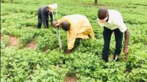
The major crops grown in Afram Plains include cassava, cashew, yams and maize, in addition to dry season vegetables. Production is rain-fed apart from the vegetables that are mainly produced by the informal irrigation sub-sector.
The farmers use minimal levels of inputs and practice shift cultivation. Productivity levels for major crops are estimated to be: 20t/ha for cassava; 22.78 t/ha for yam; and 2.7 t/ha for maize.
Empirical data shows that with application of improved technologies and improved extension services yield levels can be improved significantly to 24 t/ha for yam; 5 t/ha for maize; and 1.8 t/ha for cashew. All cassava is consumed within the district while over 80% of the yam and maize is exported to Accra and other neighbouring towns via the ferry at Ekyeamanfrom.
LIVESTOCK
A substantial number (49.1% as at 2010) of the households hold one or more type of livestock. As at 2010, livestock population in the area was 342,522 including: 64,646 herds of cattle, 63,486 goats, and 17,682 sheep. The high number of cattle is an indication of the activities of alien Fulani herdsmen and local herdsmen who have taken advantage of the vast arable land.
The animals are managed on a traditional free-range system. The live and carcass weights of locally managed animals are lower compared with animals under improved management systems. For example, the carcass weight of local cow is about 85kg compared to 150kg for those under improved management.
In the same vein, the carcass weight of local goat is about 20kg compared to 30kg for animals under improved management. Carcass weight of local sheep weighs 22kg compared to 35kg under improved management. For poultry, the carcass weight is about 1kg as against 2kg with improved management.
Cattle production is concentrated in the Dwarf Island area. Small ruminants and poultry are more evenly distributed throughout the area.
Livestock husbandry methods commonly practiced include tethering, free-range, semi-intensive, limited livestock housing and intensive management for commercial poultry layers. Most of the sheep, goats and chickens are consumed by families owning livestock or are sold within the area. However, substantial numbers of cattle are sold out of the area.
FOOD BASKET REGION OF GHANA

The Afram Plains, as a result of its massive tracks of arable lands and good agricultural weather, makes it a significant major food Basket region (FBR) in Ghana. Weekly market days in Ghana towns are normally a day in a week, but in Afram Plains, market day involved around 3 consecutive days in a week. Afram Plains, uniquely is a serious Food Basket Region in Ghana.